Oil and Gas
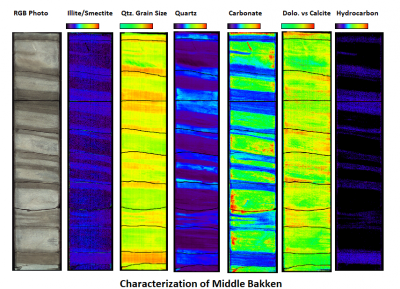
Hyperspectral Imaging is a quick, non-destructive analytical technique that utilizes energy reflectance to identify and quantify the surface mineralogy of rock core and chips. TerraCore utilizes high-resolution core photography combined with visible/short-wave infrared and long-wave (thermal) infrared cameras to quickly image the core to produce visual mineral maps of the rock core. Minerals reflect energy uniquely from one another making Hyperspectral Imaging an accurate tool for identification and quantification of sediment compositions such as:
- Carbonate (including dolomites) speciation
- Clay speciation
- Iron hydroxides
- Quartz and carbonate grain size determination
- Bitumen and hydrocarbon occurrence
As a result, hyperspectral imaging can be a useful tool in rock typing, lithologic correlation, provenance analysis, distribution studies and stratigraphic correlations among other applications as discussed and seen in the figure below.
Most mineralogy, including mineral chemistry, can be identified and mapped in the infrared regions, with grain size of specific mineral groups detectable with our state-of-the-art thermal LWIR cameras. Quantification of minerals along with mineral chemistry and grain size variations are delivered as both image data that shows the textural relationships of the minerals in situ, and digital data that can be easily imported into well logging software as curves to display mineralogical variations with depth, much like continuous XRD, alongside petrophysical logs.
The imaging process measures the entire surface of the core, making mineralogy measurements fast and continuous as opposed to spot measurements. The ability to highlight mineralogical variation within the reservoir not only increases the ability to understand porosity and permeability aspects but can also decrease costs by using hyperspectral rock typing to guide sample selection. With more accurate sampling locations selected, point-measurement (XRD, XRF, rock mechanics, thin-section petrology, porosity and permeability) data can be linked to the hyperspectral data and so upscaled to help build reservoir models that accurately reflect the compositional and mechanical heterogeneities of a reservoir, potentially leading to more efficient production of hydrocarbons.
High resolution (150 μm) visible light images are collected simultaneously with the hyperspectral data sets. The images can be accessed and scrutinized from any location at any time with Intellicore®, TerraCore’s proprietary, web-based platform that enables clients to view, interrogate and integrate their spectral data. When exported, the data can be formatted to be easily integrated with existing client data for use in other software programs and databases.