Applications
Exploration: The Power of TerraCore: Combining shortwave infrared with longwave infrared.
It’s time to gain a competitive edge. Typical hyperspectral imaging utilizes visible and near infrared sensors to detect alteration mineralogy, the most valuable application of which are usually the delineation of clay species. For some projects, this is all you need and TerraCore can certainly expertly assist. However, there are limitations on what minerals one can see and sometimes you need more.
If your next question is how can I see more in my rocks without a complicated data collation slowing down your workflow then you have come to the right place.
TerraCore combines Visible-Near Infrared (VNIR) and Short-Wave Infrared (SWIR) sensors with Mid-Wave Infrared (MWIR) and Long-Wave Infrared (LWIR) thermal sensors to give you full-range hyperspectral mineralogy. Thermal infrared sensors tell us about rock forming minerals – think silicates and a better look at carbonates – without sacrificing acquisition speed or confusing data types.
This is the power of TerraCore: full range hyperspectral mineralogy that reveals alteration and lithology minerals and texture showing you what’s really in your core. All collected with industry best acquisition speeds designed to limit onsite impact and presented on a powerful, intuitive spectral viewing platform supported by helpful geospectral experts. Think of TerraCore as your geological cheat sheet for making informed, data-driven exploration decisions.
- Start with the basics: Uncover the full mineralogical makeup of your deposit, from host rock to alteration phases. Knowledge is power and the first step to informed decision-making.
- Map it out: Get continuous, high-resolution mineral maps of downhole geology that integrate seamlessly with your 3D models. This isn’t just about pretty pictures—it’s about understanding your deposit’s structure and identifying high-potential zones.
- Accurate drill logs: Give your geologists the tools they need to focus on interpretation, not tedious data entry.
- Vector like a pro: Fast, accurate mineral chemistry detection helps you zero in on those high-value targets. It’s like having a treasure map with an X marking the spot.
Explore smarter, not harder. Reduce unnecessary exploration expenses and get to the good stuff faster, saving you time and money.
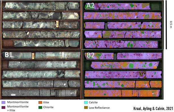
Click to enlarge image
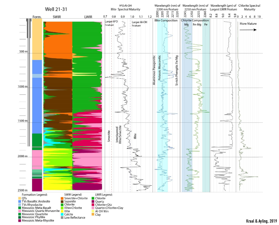
Click to enlarge image.
Mining Optimization and Geometallurgy: Real-Time Insights, Real Results
- Keep up with the pace: Our unrivalled acquisition speeds (1000m+ per shift) mean your data is never on standby. We keep up with even the most demanding production schedules.
- Fast, predictive modelling: With our advanced analytics, AI, and machine learning capabilities, we’ll turn raw data into actionable insights, helping you optimise your processes and boost your bottom line.
- Understand your ore: The physical parameters that affect metallurgy (blastability, throughput, recovery, etc.) are all controlled by mineralogy. We’ll help you decode your rocks.
- Connect the dots: Correlate point measurements with continuous hyperspectral data to create a comprehensive picture of your orebody.
- Objective, reliable results: Consistent data capture methods mean you’ll spot any changes in mineralogy right away. No more guesswork, just accurate, actionable data.
- Find the problem ones: Directly detect problematic minerals like talc, smectite clays, and fluorite that can wreak havoc on your operation—saving you potential millions per year in the process.
- Quality data in, quality data out: Our full infrared coverage (NWIR, SWIR, MWIR, and LWIR) ensures you’re getting the most comprehensive picture of your orebody.
- Data that works for you: Our numerical data seamlessly integrates with all your existing software and model types.
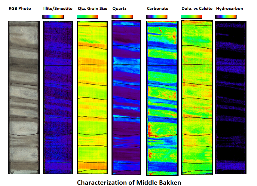
Oil and Gas: Reservoir with Confidence
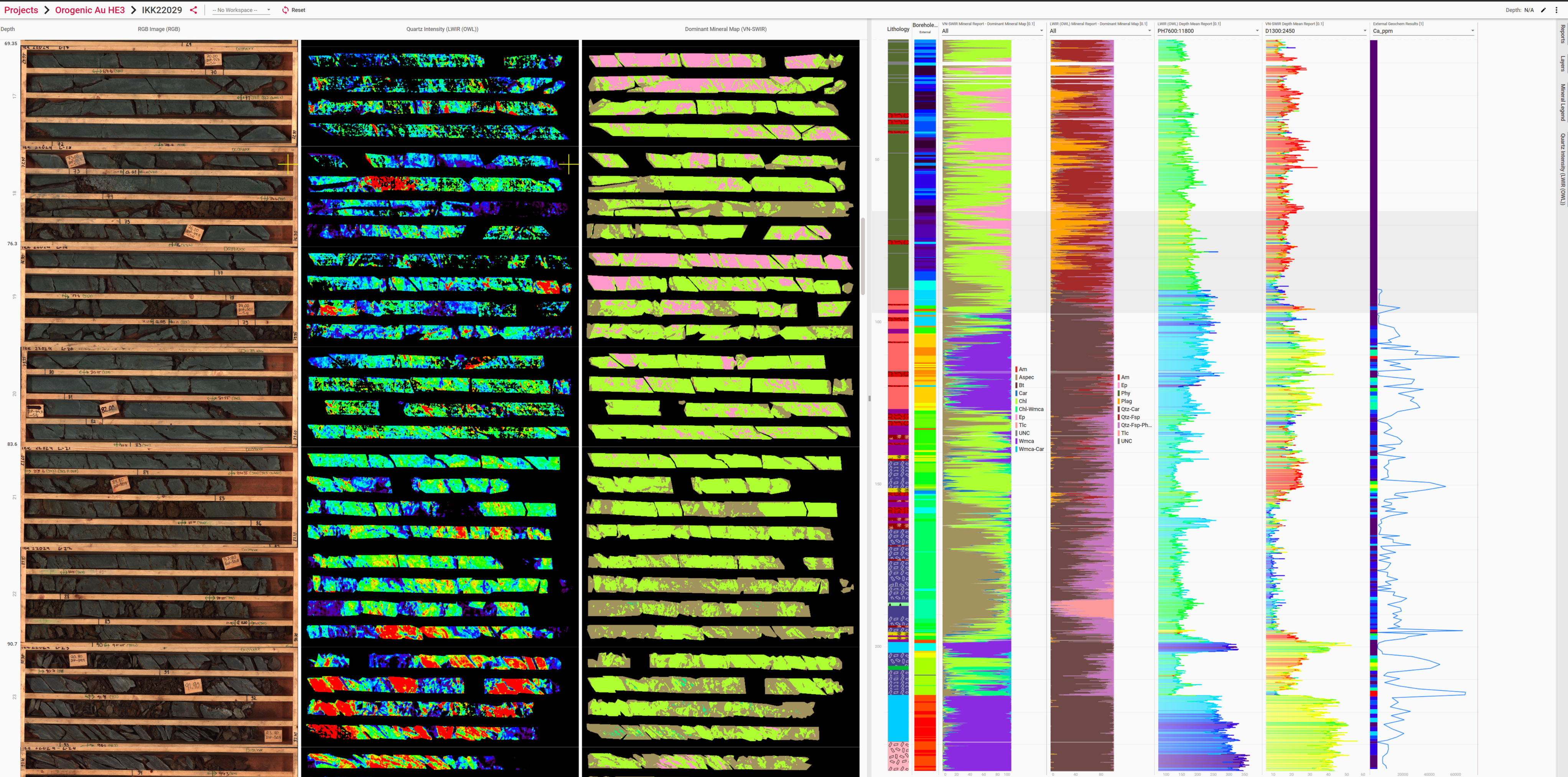
TerraCore’s full range hyperspectral core imagery is a powerful tool for the energy scientist as it provides a downhole reservoir view like never before. TerraCore is the only company that combines the Short-Wave Infrared (SWIR) with the Long-Wave Infrared (LWIR) to give you a full hyperspectral picture of your core. Not only can you see minerals of fine-grained shales and siltstones, but you can also see subtle compositional and grain size shifts in carbonates and silicates. High resolution core photography combined with full range (shortwave and longwave infrared) hyperspectral mineralogy provides downhole lithologic and facies/mineralogic views of the borehole. All data is digitized and exportable and all imagery and data is viewable in TerraCore’s powerful spectral viewing application called IntelliCore®
- Know your reservoir: Our technology directly detects minerals, mineral chemistry, and grain size, giving you a comprehensive understanding of your reservoir’s composition.
- See the whole picture: We correlate spot measurements with continuous hyperspectral data, filling in the gaps and providing a complete picture of your reservoir’s potential.
- Make informed decisions: Our detailed depth editing process ensures accurate correlation between your core data and downhole wire logs, helping you optimise well placement and maximise recovery.
- Log with precision: We assist with lithology mapping and core logging, providing the detailed information you need to build accurate geological models.
- Evaluate heavy oil: We can quantify and qualify minerals within the bitumen zones, giving you a deeper understanding of your reservoir’s complex composition and flow properties.
The bottom line? Hyperspectral imaging empowers you to make smarter decisions about drilling, recovery, and the economics of your reservoir.
Click to enlarge image.
Click to enlarge image.
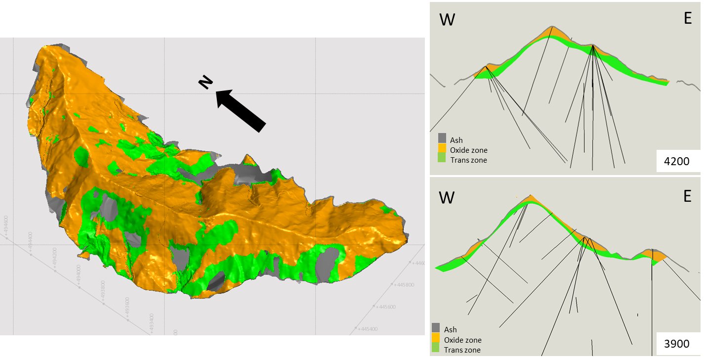
Geothermal: Precision at Pore Level – Smarter, Faster, and with Less Risk
Geothermal projects are high-stakes endeavours. You’re drilling deep, investing heavily, and banking on the perfect conditions at depth. That’s where hyperspectral imaging comes in. Understanding minerals can unravel ambient clues such as temperature, porosity, and permeability. It’s your secret weapon for de-risking your geothermal projects and maximising your return on investment.
- Pinpoint the sweet spot: We detect the presence (or absence) of clays, giving you a reliable temperature proxy to identify the hottest zones in your reservoir.
- Unlock flow potential: By analysing mineral texture (grain size and crystallinity), we can accurately evaluate porosity and permeability—crucial information for predicting fluid flow and optimising well placement.
- Plan with certainty: Mineral presence tells you the historical fluid temperature and flow patterns, leaving you with confidence in the development of your Enhanced Geothermal System.
- Data that tells the whole story: Our continuous core measurements seamlessly integrate with your point measurements, creating a comprehensive, objective dataset that covers your entire project.
Deep hole drilling is expensive. Our technology helps you minimise risk and maximise your chances of success.
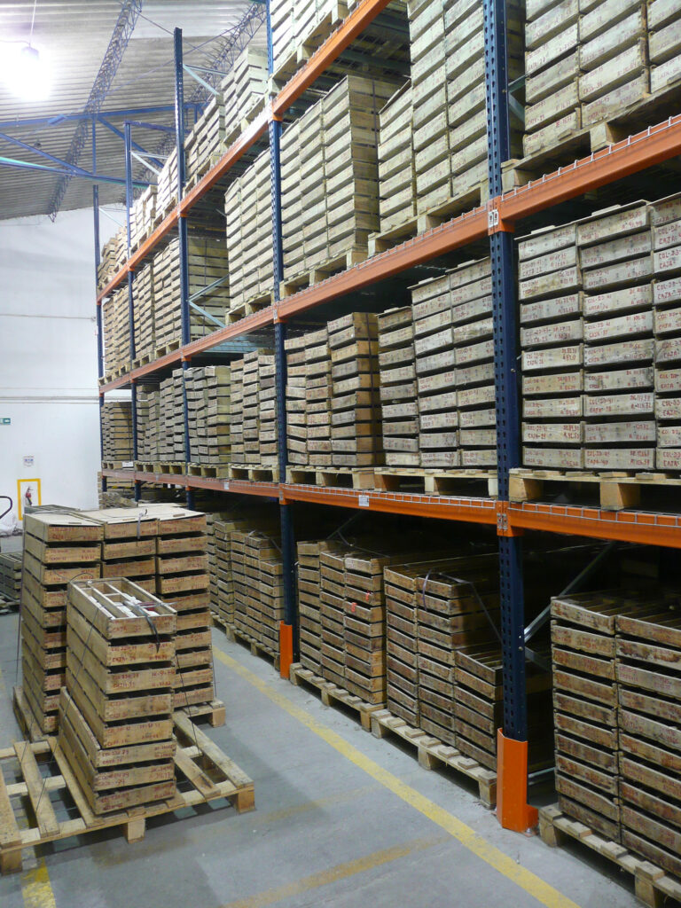
Digital Core Libraries: Secure Your Legacy, Fuel Future Discoveries
Your drill core is a treasure trove of geological knowledge—don’t let it turn to dust in storage. We transform your core into a digital time capsule, preserving its value for future generations. Imagine a comprehensive, searchable, and interactive digital archive of your entire core library—accessible from anywhere, at any time. That’s the power of TerraCore’s digital core library solutions.
- Rapid digitisation: We image entire core collections with lightning speed—250km in just 6 months! Say goodbye to endless storage costs and hello to efficient, streamlined access to your valuable data.
- Live, accessible data: Your digitised core lives on in our secure, cloud-based IntelliCore® platform. Control who sees what with customisable access permissions, ensuring your data remains confidential.
- Flexible options: Choose the solution that fits your needs and budget. We can handle the entire digitisation process for you, or we can empower you to do it yourself with our system rental or purchase options. We offer training and support, so you’re never alone on your digitization journey.
Open the door to discovery with TerraCore. For public entities that consent to making your data publicly available, you foster collaboration, drive exploration in your region, and contribute to the advancement of geological knowledge.
Your legacy lives on, inspiring future generations of geologists.