How GeoSpectral Imaging™ works
The science behind The GeoSpectral Image™
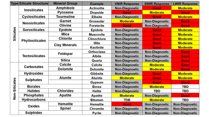
Infrared images are captured using an appropriate illumination source reflected off a sample and measured by an imaging spectrometer. Specific bonds present in the sample cause absorptions in the measured reflectance spectra. These spectral signatures then reflect characteristic features that allow mineral identification and mineral variation determination. Minerals are detected in the infrared imagery depending on the bonds present in the sample and the infrared wavelength range measured.
The infrared and mineral detection
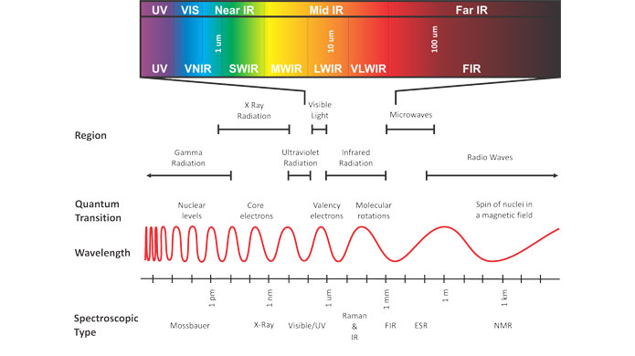
We divide the electromagnetic spectrum into different wavelength ranges, namely: visible to near-infrared (VNIR); short wave infrared (SWIR); and long wave infrared (LWIR; also often referred to as thermal infrared). The SWIR and LWIR regions are particularly important for mineral identification. Hydroxyl and carbonate bond related vibrations are typically measured in the SWIR, resulting in the identification of phyllosilicate and carbonate minerals. Clay minerals, micas, chlorites, and different carbonate species are also detectable in this region. Longer wavelength ranges are necessary to detect the fundamental vibrations related to silica and aluminum. Thus, in the LWIR region, quartz, feldspar and other silicate minerals can be detected and identified.